In the blog this month:
Do the California Floods Mean Anything for the Drought?
Exploring More of the Potomac Valley
January 2023 Gallery: Old Friends, New Visitors

Wind and rain uproot trees to block Highway 101 in far northern California (Washington Post)
What do the six atmospheric rivers mean for the California drought?
Maybe nothing. Maybe something. Too early to tell.
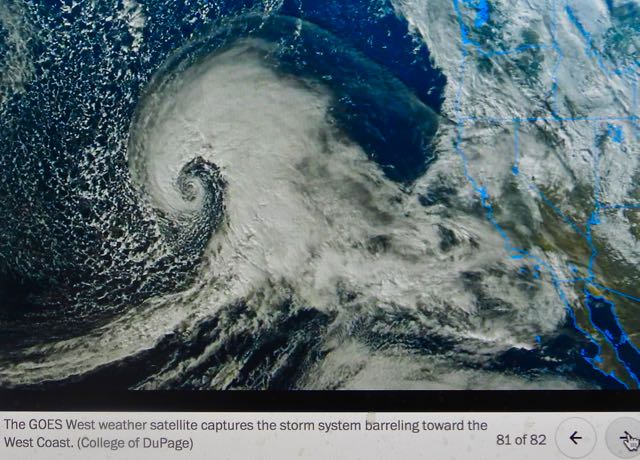
It was weird for me to try to follow from 2500 miles away the weather reports from the National Weather Service as the six “atmospheric rivers” blasted across California from late December to mid January. Before we moved back to Virginia last spring and summer, we were always in the middle of the weather tumult that is California. I was always fretting about the state of the plants in the garden, and bemoaning the increasingly obvious impacts of climate change, namely the record drought and the steadily rising average temperature. But now my garden is a fond memory, and all I can do is watch from afar, and wonder if the screaming headlines about floods and devastation match what is true on the ground in the very different parts of the state.
As a Californian, I never assumed that the weather in one place in the state would be the same as in others. California is a huge state; it spans 800 miles of the Pacific Coast and almost 300 miles from ocean to mountain peaks. It has as many or more micro-climates as counties (58). On the same summer day, the high temp in Davis could be a sun-baked105 and the high temp in Oakland, 70 miles away, could be 51, blustery, and cloud-covered.
So it was disorienting to read national headlines day after day proclaiming the devastating floods “across California,” as if the effects were the same everywhere. So I did what I would have done had I still been there: I checked the National Weather Service for the rain totals for different parts of the state, and, sure enough, found big differences. Yes, the coast in the far north, Humboldt County, received close to 50 inches of rain, truly alarming. Coastal sites farther south, including Santa Cruz and Santa Barbara, received a way-above-average 25 inches since the start of the “water season,” which is measured beginning October 1.


In contrast, my region, around Sacramento, and the LA/LongBeach region, where our daughters live, had almost 14 inches, more than average by January, but not remarkable–except that the previous three water seasons produced less than half of average! Even more sobering is that Fresno, in the heart of the agriculture-intensive Central Valley, has received only 9.3 inches this water season, about average.
So what will the rain totals mean for beating the drought? Well, the state water authority has already gone out on a limb by allocating to agricultural producers 30% of all the water it projects will be in the state’s reservoirs this year. That’s a huge increase over the 0-5% it has allocated the past two years as reservoir stocks have steadily fallen.
This year’s rosy projection is based on hope that the snowpack in the Sierra Nevada–which is now more than 200% of average in January–will not disappear by late spring, which it did last year, when a rainy October and December 2021 were followed by 9 straight months of no rain. Of course, the water authority always hedges its bets by saying that this year’s allocation could change, if no more substantial rainstorms arrive.

Engineers measure Sierra snowpack, Jan. 5 (Photo: Kenneth James, AP)
So, the bottom line? Despite the screaming headlines and dramatic photos, most of the state is and will still be in a drought, unless more atmospheric rivers come out of the Pacific from February to April.
Meanwhile, we sit comfy and cozy in our Northern Virginia winter, where it rains moderately once or twice a week, and hasn’t yet snowed at all. But that’s another climate change story for another time.
Exploring More of the Potomac Valley
After last month’s anniversary visit to the Potomac River towns of Harper’s Ferry and Shepherdstown, West Virginia, and to the Antietam National Battlefield on the Maryland side of the Potomac, we ventured early this month to a few other towns in the Maryland part of the Potomac Valley. Once you get beyond the sprawling, highly-developed suburbs west of Washington, DC, such as the town in which we now live, and whose fast-paced lifestyle I described in September’s entry, you will find life in that part of the Potomac Valley that is thoroughly rural.
Well, maybe not that rural. If you drive the two-lane highway between tiny Point of Rocks, Maryland, and completely suburbanized Leesburg, Virginia, the traffic jams don’t say country, nor does winding Highway 9 west of Leesburg to tiny Hillsboro during commuting hours. Nor does Interstate 70 in Maryland, which for 60+ years now has been steadily transforming the widening swath of its route through the western part of the state into a loud, fuming, fast-fed creature that will run over anything in its path. (Well, maybe I’m being too dramatic, but I doubt it.)
But if you slowly explore the tranquil, curvy oblong of country between Poolesville, Maryland, on the southeast; Williamsport, Maryland, on the northwest; the Potomac River on the southwest, and Interstates 70 and 270 on the northeast, you’ll be treated to some of the most beautiful country you can imagine. That’s because you’ll have to slow down on old roads that conform to the shapes of the hills and water-carved valleys, and because there is lots more open or forested land than there are buildings or people.
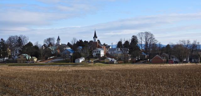
Burkittsville, Maryland
On the most recent day we visited, we followed the Potomac to Lovettsville, Virginia, where we crossed the river to Brunswick, Maryland, then eased up the narrow highway to little Burkittsville, where we stopped for the photo, above, across the harvested cornfield to the 18th century crossroads.


Our destination was farther up the road toward Middletown, where we took twisty sideroads to the Hawker dairy farm and its Moo Cow Creamery, where we conversed with the co-owner and purchased some of their home-crafted cheeses.
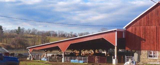
Hawker Farm and Moo Cow Creamery, Middletown, Maryland
From Middletown, we proceeded along old U.S. Route 40, on the roadbed of the first National Road, which had been authorized by Congress in 1802 and completed from Baltimore to Wheeling, Virginia, in 1818. We passed through Boonsboro, then on to Funkstown, and finally into the 18th century town, now city, of Hagerstown, which celebrates its historic downtown, though Hagerstown’s being on the Interstate 70 path means that its character has changed dramatically in the past century. Part of the attraction of this region for us is that Jean has traced some of her ancestors back to the 18th century in the Hagerstown area and nearby Pennsylvania, so we especially appreciate how this land has retained so much of its character from that time.
January 2023 Gallery: Old Friends, New Visitors
Run the cursor over the photos to see the description.
This month’s gallery features a few experiments with color and light, as well as typical attempts at realism. Kudos to the subjects for their cooperation, but I also appreciate their making me struggle. Kudos also to my Nikon P950 with the 83X Optical Zoom.


Four house sparrows on the sidewalk by lake


Red-shouldered hawk launches above Lake Cameron, Jan. 16
Launching into February and new adventures…
