
An upside-down photo of Lake Cameron, fitting our upside-down winter
In this month’s blog entry:
An Upside Down Virginia Winter
DC Tidal Basin and Its Marvelous Trees: In Danger
California Upheaval
March 2023 Gallery: Birds Exult, Turtles Emerge–Songs and Sightings

Three double-crested cormorants, new here this week
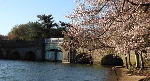
An Upside Down Virginia Winter

As I noted last month, the National Park Service predicted that the cherry blossoms along the Potomac Tidal Basin in DC would bloom early, and so they have, as have the blooms in our own small community (photo, above). So winter came and went with no measurable snow, and now, still in March, spring is busting out all over.

Blooms along nearby Lake Newport
The high temps this week have reached the 70s, and nothing in the forecast sees us getting back down to freezing. Now don’t get me wrong. I’m enjoying the warmth and the explosion of blooms. That’s a big upside. The birds are ecstatic, as you’ll see and hear later in the entry. But the downside is that this pattern fits just too nicely into the gradual warming that betokens the changing climate, and I fear that our happiness now here in Northern Virginia keeps us blissfully uncaring about the years-long drought plaguing much of the Western US and so much of the developing world. Not to mention the melting polar icecaps causing sea level rise along coasts and around islands everywhere.
Even more troubling is that this spring-y DC region is the home of the US government, which should be moving hard and fast to take us away from the fossil fuels that are the main contributors to global warming. But with our local weather so perfectly balanced between sun, sufficient rainshowers, and magnificent blossoms, the fragile, embryonic commitment to defeat climate change can seem pretty abstract and far from urgent to legislators who are themselves basking in this colorful, fresh late winter display.
Yes, it’s mighty hard to combat short-term thinking and the power of the status quo, especially if your status quo is a gorgeous late March.
Still, science keeps trying to fight the stick-in-the-mud thinkers. Check out what NASA hopes is a convincing video chart: the climate spiral, which shows dramatically how the average temperature of the planet has increased faster and faster in the past forty years.
DC Tidal Basin and Its Marvelous Trees: In Danger

Cherry blossoms on March 19 by the Potomac River Tidal Basin
Having heard last week on the news that the cherry blossoms in DC were in bloom, and wanting to beat the crowds who would descend on the Tidal Basin of the Potomac to see them, we drove in early on Sunday, March 19, to find close-in parking. We succeeded in arriving before 8 AM, and exited the car into a stiff, cold wind that seemed anything but springlike. But a short walk took us to the Basin, which spreads out in front of the Jefferson Memorial and provides a great view of the Washington Monument (photo above) no more than a mile away.

Cherry blossoms along the Potomac River Tidal Basin toward the Jefferson Memorial
The 3000 trees in the area of the Basin are mainly of the Yoshino variety and were a gift to President Taft and First Lady Helen Herron Taft in 1912 from the city of Tokyo. There is an intriguing history surrounding this gift and about later events in this history, including what came to be known as the “Cherry Tree Rebellion” in 1938, the year the Jefferson Memorial was built. But as a student of the Potomac Valley, I was more intrigued by the Tidal Basin itself and how it came to be.
Building the Tidal Basin, 1880s. Seventy-five miles from its outlet into the Chesapeake Bay, the Potomac at Washington, DC, is a tidal river, its flow and depth heavily influenced by daily tides. At high tide, Potomac waters used to spread out into mudflats that, intensified by silt from farm runoff and city sewage, became famous to 19th century visitors to the Nation’s Capital for its summer stench and flying insects. In the 1880s, the Tidal Basin was constructed to be deep enough (10 feet) to capture the tidal flow in its 107 acres and then, at low tide, to send the waters back down the adjacent Washington Channel and into the Anacostia River, which then entered the Potomac south of the city. A key feature of the Tidal Basin is its inlet gates, which open as the tide rises and then close when the tide turns low.
Tidal Basin bridge and inlet gates, plus cherry blossoms!
Threats from Climate Change: Today, the Basin is an internationally famous tourist destination because of its cherry trees, many monuments to national heroes, and splendid walks. But it, too, is not immune to the effects of climate change. A sign along the walk alerts visitors: “Due to sea level rise and the settling seawall, the Tidal Basin and East Potomac Park are flooding regularly. Many cherry trees have died…and the sinking seawalls pose a danger to visitors walking on them.” So reconstruction has begun and parts of the Park are closed. And the threats to the Park are just one symptom of the overall threat to the Nation’s Capital from the increasingly wet weather brought about by global warming. See this Washington Post article from Dec. 2023.

California Upheaval

Santa Cruz Sentinel, March 24
It has been 6 years since the 3-mile wide Yolo Bypass, the massive engineered floodplain of the Sacramento River, was this full. That was in water year 2016-17, when some 45 inches of rain fell over six months, ending the 5-year drought from 2011-16. The Bypass, 41 miles long and covering 59,000 acres, was created by the US Army Corps of Engineers in the 1930s, and became the prime growing area for California rice, which is shipped worldwide. It’s also a wonderful bird sanctuary, a prime stop on the Pacific Flyway. Jean and I birded there occasionally during our 16 California years.
But its primary purpose is flood control, and the Sac Valley is so lucky to have it now, in this upside-down season of unexpected atmospheric rivers and record Sierra snowfalls. Other areas of California have not been as well prepared, including the vital agricultural regions near Salinas and Watsonville in the Salinas and San Benito valleys, where recent flooding has forced evacuations and destroyed farms and homes, especially in the town of Pajaro (see below), home to many farm workers.
Also hard hit are Tulare and Kings counties in the Kings, St. John’s, and Tule river valleys, among the richest agricultural areas in the world. Tulare is named for Lake Tulare, which flourished for thousands of years during the annual cycles of flood and dry, and provided sustenance for the native Yokut people.

19th century boundary of Lake Tulare (LA Times, March 26)
But when white settlers came in the later 1800s and began diverting water through dams and levees for their commercial crops, the lake slowly disappeared, along with the Yokut communities. Tulare had been the largest fresh water lake west of the Mississippi, four times larger than Lake Tahoe, but when I first heard of it in 2007, I thought of it only as a ghost from long ago. Meanwhile, in California’s many years of drought beginning in 2011, not only was the lake a ghost, but so was much of the aquifer below the lakebed, as the thirsty fruit trees, which had been planted over more and more acres, required ever-increased pumping with ever deeper wells–and the ground slowly sank as the water level fell.
Well, now the lake has returned, can we say with a vengeance?

19,000 acres are already underwater, and with months of snow runoff to come, the new Lake Tulare may reach its former size of over 70,000 acres. Now the greedy growers are struggling to find out how to rid themselves of this troublesome ghost. How tragic that they and their previous few generations of owners had thought themselves impervious to catastrophe, and so had made so many workers and consumers dependent on their manipulations of land and water.

Store owner in flooded Pajaro, from “California Levee Failures Mount as Storms Continue Relentless Drive,” Tim Arango and Shawn Hubler, New York Times, March 14
March 2023 Gallery: Birds Exult, Turtles Emerge–Songs and Sightings
Sometimes I feel like the rabbit, above, in the thicket at the north end of the lake: hidden but reasonably safe in our little lakeside sanctuary, as the traffic speeds by outside our community. The birds fly in and out, sometimes stay for a long while, and so do our other citizens, human and non-human. It’s a magical, musical place. (As always, run the cursor over each photo to see the caption.)


Some days the birds are hard to see, but the choir is rarely silent (silent only if a hawk is around!). Day after day, the choir is in full throat, as in this clip:


The songbirds always make their presence felt, but other citizens are permanent residents or occasional visitors:


Definite harbingers of spring are our many Northern red-bellied cooters (what a great name!), who only come above water from their homes in the bank beneath the lake when the temps rise into the 60s and above. Oh how they love the sun! And a hearty welcome to the babies!


To sing the finale to our March entry, here are three of our favorite choir members performing solos.
And on to April!
